This study addresses the conflicts emerging from differing socio-economic goals across various governance levels and explores the alternative scenarios to balance the socio-economic goals and ecological resilience on both overall and local scales. Focusing on the Huangshui River Basin in China’s Qinghai-Tibet Plateau—a region facing the combined pressures of climate change and human activity—the study reveals significant inconsistencies in national, provincial, and local planning documents regarding socio-economic goals and ecological resilience. As a critical ecological shelter at the national level, an economic hub for the province, and a center for local development, this basin serves as an illustrative case of the challenges involved in balancing socio-economic goals with ecological resilience across multiple governance scales.
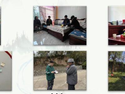
From 2021 to 2024, we conducted three field surveys, each lasting 2–3 weeks. Our study involved roundtables with government agencies, workshops with land stakeholders, and extensive field investigation. The government roundtables included representatives from central government agencies, provincial departments in Qinghai, local governments in Xining and Haidong, as well as county and township-level authorities. We collected and analyzed publicly available planning and spatial policy documents from these different levels of government, focusing on the divergence in spatial development strategies and objectives for urbanization, agriculture, animal husbandry, and ecological protection. Land stakeholders workshops included large-scale landowners, community leaders, village administrators, and individual farmers and herders. These workshps explored how planning objectives at various governance levels impacted stakeholders and their visions for the future. Additionally, extensive fieldwork was conducted to observe the local environment, particularly drought-prone areas, disaster-prone areas, ecological resettlement villages, and key ecological restoration projects.
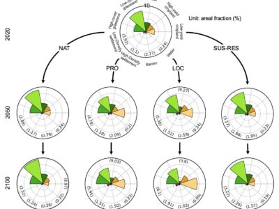
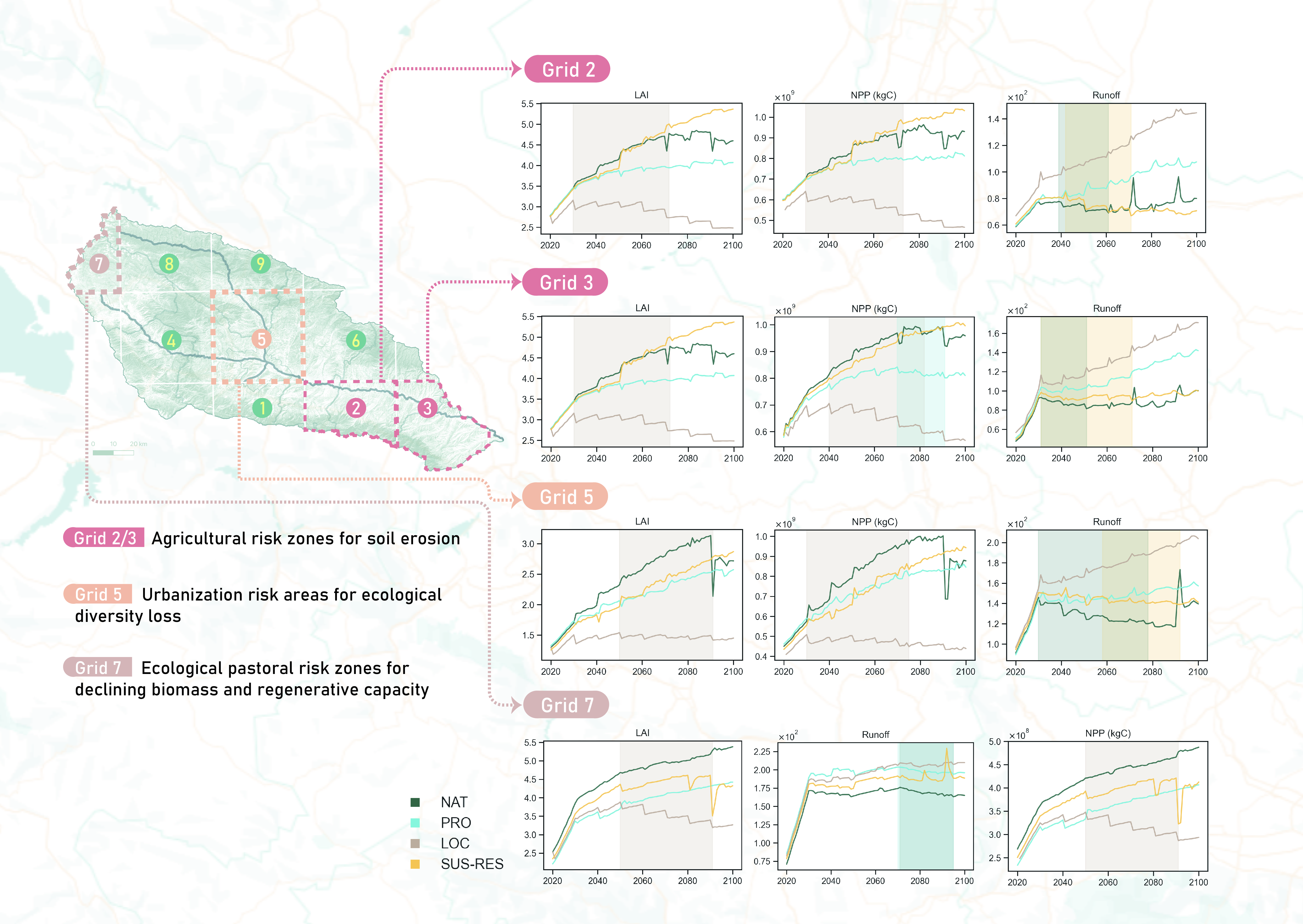
Using the Google Earth Engine platform, we analyzed long-term land system changes in the basin from 1990 to 2020, investigating the drivers behind these changes. We extracted spatial strategies and socio-economic objectives from planning documents at different governance levels, projecting them linearly to 2050 and 2100. The CLUMondo model was used to simulate future landscape configurations, while the LPJ-GUESS (Lund-Potsdam-Jena General Ecosystem Simulator) was employed to measure changes in physical ecosystem parameters. We selects three key variables—Net Primary Productivity (NPP), Leaf Area Index (LAI), and runoff—as indicators of the ecosystem’s recovery potential, resistance, and disturbance tolerance, respectively. These variables capture different facets of ecological resilience. Significant reversals in any of these trends indicate negative feedback loops on socio-economic objectives, prompting policy adjustments to mitigate further degradation of ecosystem services.
Thus, we establish a framework to describe a dynamic feedback loop linking national, provincial, and local socio-economic objectives with multi-scale ecological resilience and landscape patterns. The framework comprises four main steps: (1) Cross-scale sustainability and socio-economic objectives-setting: This step involves conducting interviews and analyzing planning documents at three governance levels—national, provincial, and local—to understand the perspectives of sustainability and socio-economic objectives at each level. The aim is to identify the possible range of scenario parameters for socio-economic objectives within the basin. (2) Spatial simulation of multifunctionality landscape: Utilizing the CLUMondo model, this step simulates landscape configurations that meet multiply socio-economic goals, clarifying the ecosystem’s functions and structures spatially. (3) Measurement of ecosystem resilience indicators under climate change: The LPJ-GUESS model is employed to simulate and assess changes in ecosystem resilience indicators in response to projected climate change and evolving landscape configurations. (4) Overall and local feedback and iteration: A long-term sequence analysis method is used to diagnose trends in ecosystem resilience indicators. This feedback informs iterative adjustments to the socio-economic objectives setting in Step 1, ensuring that both overall and local resilience in the basin remains aligned with desired trajectories.
Our findings highlight the risks associated with setting overly ambitious socio-economic goals, which can lead to significant losses in ecosystem resilience, especially in ecologically fragile areas of the basin. These risks are likely to intensify if not addressed. Furthermore, this study demonstrates socio-economic goals can be pursued in a way so that they do not compromise ecological resilience, if we plan and manage carefully. China is currently undergoing a reform of its territorial spatial planning system, achieving significant progress in coordinating the interests of various levels and in the transmission of planning goals. This study offers a new perspective that integrates sustainability and resilience across multiple governance levels.
The scenarios were made in: 2024
The scenarios look out to: 2050, 2100


